Cloudcroft, Ruidoso, & Tucumcari

Sat @ Cloudcroft I rode the race course in the AM. Almost all the single track is rocky as in like baseball sized rocks that are not anchored to the ground. Ride right behind a rider and watch the line change because of the rocks rolled free. The first part went thru a fuels reduction cut forest, the skidders beat up the informal trails that are being reridden in. It dropped out onto a logging road for seemed like miles then dumped down the down hill grown in double track w/ some h2o bars. Gravity was my friend as I zoomed down hill. I watched the elevation drop on the Edge knowing I would have to climb back uphill. The downhill stopped just b4 Bailey Canyon road @ the highway 82  switchback. The uphill was up a power line, straight uphill @ 11%. Then a woodsy single track to finish. I shared the GS map and the garmin data w/ the bike shop.

I hung around town. I parked right on Burro street, the former main street. A pick up w/ a big camper pulled in right next to me. Driver called out my name. I didn’t recall his name but I remembered him. We met originally in Moab on one of my Thanksgiving trips. Then again @ Breckenridge 2 years ago. Later that afternoon he found me @ my solitary camp spot out on the race course road. He is now racing the multiday races. Enjoyed our conversation.

The first racers take off @ 10:00 meaning that I needed to be gone  or be trapped by them. I made it on time.

Sunday I drove to Ruidoso nearby. I found little detailed riding info but a new bike shop that unfortunately was closed. I walked the main drag which is all about tourist shops. I bought an egg beater @ a well stocked kitchen store. I checked out straw cowboy hats, I need to replace my fur felt hat w/ straw for summer. I visited a handmade soap shop and learned more about making soap. I added another bar to my collection.

Weather threatened rain, actually a few drops fell. I decided no ride. The bike shop is in with a fitness club which is not part of my fitness program. I paid $10 for a tepid shower.

Afterwards i drove out to FT Stanton BLM land looking for a primitive camp spot. I found a slightly developed campground @ a cave entrance. Cave was closed. I the 4 spots to myself. After dark I did not put the mosquito netting up soon enough to prevent an invasion of moths flying to the light above my computer.

My health continues to suck. I am not feeling well generally making eating almost nauseous. I just don’t want to exert myself.

Monday was another drive no exercise day as i drove back roads to Tucumcari, NM. Listen to the words from Willin’ by Little Feat. I have now been to the 4 T’s in the song. I learned that the Blue Swallow motel on Main st: RT 66 had local themed post cards. I stopped in and met the new owner. He and his wife were spit out by corporate America causing them to seek their own version of corporate America. They bought the motel which is world renown. The 2 of them had paint on them from remodeling. they are from Michigan. He said recently all 8 units were filled w/ foreigners, no English spoken.

I drove east out of town on RT 66 until I-40 swallowed it up to check out the local airport for a camp spot. Not even a sign off the county road for the entrance. The terminal is undergoing renovation. I found a guy wearing a uniform shirt and asked him if it was OK to park for the night. Guy was perplexed about my request. He apparently lacked authority but gave me permission anyway. I watched the sun go down w/ the truck traffic out on the interstate providing the back beat.

My back roads went thru flat range land. Lots of grazing acreage where the grasses were golf course short except for the cholla cactus. Some was planted in wheat. Lots of failed farms and ranches. I am near No Mans land written about by Timothy Egan in the Worst Hard Times. I plan on driving up to the OK panhandle to Boise City which was a central town in his book.

Tomorrow I am driving into Texas to Palo Duro SP to ride in the 2nd largest canyon in the US, that is per an advertisement for a mtn bike race there. Going thru Amarillo.

Sorry to you NM folks who offered to share some rides. I am seeking broad leafed trees, shade, and water.

Friend Charlie from eagle, CO is visiting Sedona. he called today. I learned that afternoon temps are 99 degrees.

Cloudcroft

Last night I camped up Bailey Pass road. I saw perhaps 6 elk @ a h2o source on the drive up. And several horses around my camp.

Today I finished the drive up to Cloudcroft @ 8900′. I arrived @ High Altitude shop just b4 10:00 opening. I met Matt, the owner. We chatted for awhile. He is sponsoring a mtn bike race Sunday, High Altitude. Cloudcroft is almost 5,000′ higher than the populated desert where most racers will be coming from. The altitude is just killing me.

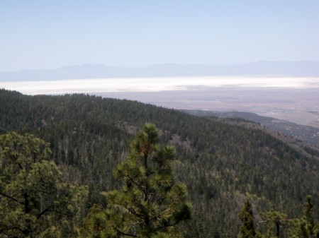
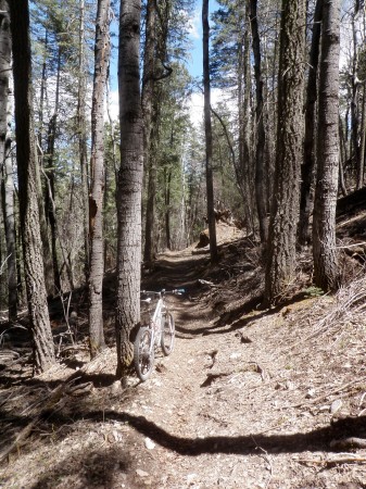
Matt gave me a map of the Rim trail, T105, and suggested ride direction which I heeded: Park @ northern end, ride the hwy S to Southern trail end, and then ride the trail back. Six miles of pavement, stated 10 miles of trail that turned out to be 11 with 1979′ climbing, topping out @ 9300′. I considered riding the trail out @ back, considered operative word. Smooth pavement riding. The trail in parts was very rocky, some of it loose baseball sized but sharp edged. Mix in some roots and a trail beat by dirt bikes. Elevation was my challenge as I was continually winded on the shallowest of climbs. Great view out to west to White Sands which are blindingly white off in the distance.

White Sands

A dirt bike overtook me. i stopped him and told him the trail was closed to motorized vehicles. He said it was open to dirt bikes. I lacked the knowledge other wise I would have blocked his forward progress. Back @ the trail end I saw the dirt bike closure sticker. Upper 8500′ elevation in mixed Doug Fir, P-pine, and aspen trees.

Deep tree cover

Even saw several banana yuccas. No running h2o. Some oak mixed in that had not leafed out. Deep tree cover riding.

Washed sweat off. Drove back into town. I walked the several blocks of town. I am parked on the old main st. Matt told me friends of his are playing @ the local watering hole @ 9:00. He offered me a place to park just outside of town. I might drive out there for the night then see if i have what it takes to walk back into town for entertainment.

Did you 420 on 4/20? I was premature, couldn’t wait.

Thrashed

Tues eve I rode w/ the Gila Hike and Bike shop ride on Gomez peak 4 miles n of town. Mostly older guys that got after it. Riding in P-pine, alligator juniper and some prickly pear mixed in. Tree cover higher than me. Short ride but intensity made up for shortness. I hung @ the back pushing myself harder than when i ride by myself. We rode part of the Continental Divide trail. The ride finished like it started: wham bam these guys were ready to ride and ready to drive back home. I drove up to where we crossed the CDT to spend the night.

Wed I drove back to town and bike shop to learn of other trails. I learned about Signal Peak trail that was GPSed and put up on their web site. I loaded the course onto my edge 305. No map to purchase forcing me to rely on the gps. Casual review of ride showed 3105′ climbing, just under 3 hours ride. I can do. The ride started @ 7165′ topping out @ 8990. First 8 miles climbed on logging roads. I was beat on the climb from the exertion and not eating. Elevation is a factor. Sedona riding is not about long slogs. Logging road up and CDT down then a mix of old trails and roads. Evening was getting close and I did not know where I was other than the icon on the edge screen. I was managing energy stores and time. i was becoming concerned. Finally i hit the paved road i drove in on. I decided that I would ride the road back instead of trying to follow the course. I misunderstood where I was relative to my van, I had 2 direction choices, I picked the wrong one and road 1 1/2 miles downhill in the wrong direction. I parked @ mp 14, I saw 16 up to 17 which told me I was headed away from rest and beer. I climbed back up the paved road, finally the course joined the road and I saw my van. Whew. I was beat to submission. I sat in my chair for minutes b4 i sipped a beer. remarkable that I did not cramp afterwards. My data was 24.46 miles, in 3 hrs 42 mins, climbing 3507′. Finally a calorie burn of 2042 cals.

I spent the night @ the TH.

Friend Jason from Sedona turned me onto these healthy supplements i have been eating. I noticed that the fat deposits on my body are shrinking. I hope my body is changing stripping fat from my body. Headaches are strangely occurring still, I have discovered no discernible pattern.

Today so far I have driven into town, filled  fuel tank, bought shirt, and done my wash. Plan is to drive to Alamogordo and learn about riding in Cloudcraft and Ruidoso. Hi to 2 readers who volunteered riding around Albuquerque.

Mountain Flyer mag had an advertisement for 24 hours in the canyon, Palo Duro, near Amarillo, TX that I will check out on my way to the Ozarks.

Quite a refreshing experience to see h2o flowing in creeks and big tree cover indicating h20. yesterday i crossed the same flowing creek maybe 5 times, cold temp.