
Excuse the visible coding.
<!– /* Font Definitions */ @font-face {font-family:”Cambria Math”; panose-1:2 4 5 3 5 4 6 3 2 4; mso-font-charset:1; mso-generic-font-family:roman; mso-font-format:other; mso-font-pitch:variable; mso-font-signature:0 0 0 0 0 0;} @font-face {font-family:Calibri; panose-1:2 15 5 2 2 2 4 3 2 4; mso-font-charset:0; mso-generic-font-family:swiss; mso-font-pitch:variable; mso-font-signature:-1610611985 1073750139 0 0 159 0;} /* Style Definitions */ p.MsoNormal, li.MsoNormal, div.MsoNormal {mso-style-unhide:no; mso-style-qformat:yes; mso-style-parent:””; margin-top:0in; margin-right:0in; margin-bottom:10.0pt; margin-left:0in; line-height:115%; mso-pagination:widow-orphan; font-size:11.0pt; font-family:”Calibri”,”sans-serif”; mso-ascii-font-family:Calibri; mso-ascii-theme-font:minor-latin; mso-fareast-font-family:Calibri; mso-fareast-theme-font:minor-latin; mso-hansi-font-family:Calibri; mso-hansi-theme-font:minor-latin; mso-bidi-font-family:”Times New Roman”; mso-bidi-theme-font:minor-bidi;} .MsoChpDefault {mso-style-type:export-only; mso-default-props:yes; mso-ascii-font-family:Calibri; mso-ascii-theme-font:minor-latin; mso-fareast-font-family:Calibri; mso-fareast-theme-font:minor-latin; mso-hansi-font-family:Calibri; mso-hansi-theme-font:minor-latin; mso-bidi-font-family:”Times New Roman”; mso-bidi-theme-font:minor-bidi;} .MsoPapDefault {mso-style-type:export-only; margin-bottom:10.0pt; line-height:115%;} @page Section1 {size:8.5in 11.0in; margin:1.0in 1.0in 1.0in 1.0in; mso-header-margin:.5in; mso-footer-margin:.5in; mso-paper-source:0;} div.Section1 {page:Section1;} –>
Peaceful sleep on side street in Alliance, Ne. Breakfast at the curb.
Drive towards Chadron, becomes hillier, P-pine snags from fire 2 years ago.
Stop @ Chadron SP. Remember 1 reviewer saying that this was a technical ride. Receptionist disagreed, trails in park were mowed and there were a few that left Sp but nothing really acceptable. She steered me to Herb Peterson in Chadron at Ship Shape on Main. I found his shop. He was cutting a man’s hair and started talking rides w/ me. He had a tanning bed in a side room and towards the back was a bike shop, the only 1 in town, and a barber shoppe street side.
-

- lay of land, prarrie, hidden goatheads
-
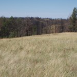
- NW corner of Nebraska is not flat
-
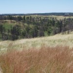
- trail went along top & dropped down into canyon below
No trails are marked, he gave me some complicated instructions about a fence and canyons and auto gates. I was confused. I followed instructions to arrive @ the “trailhead”. Single tight lane road climbed out of a canyon on to plateau. Exposed to the wind. Checked w/ instrument & it was gusting to 15. With the Brunton I am able to, per instrument, state how hard the wind is blowing.
Bike feels like it has a flat rear tire like PUSH said it would but it was just the correctly configured shock working as it should. Rode off believing I was following his instructions. He also said that because the trails don’t get ridden down they just follow their front wheel. The topography is confusing and my directions changed frequently leaving me confused & counting on the compass in the EDGE computer.
I dead ended against a fence w/ no sign of single track and I turned around. I noticed that the rear did feel like a flat. Yep, goatheads and the rear was leaking fast. I was a short distance from van so I pushed back to van.
I pulled multiple heads from the outside and 2 that deeply penetrated the casing. I replaced the tube w/ the spare from my pack & put a new tube in my pack.
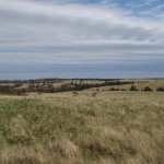
Understanding the land: US Dept Of Agriculture: Nat Grasslands like Nat Forests but w/ fewer trees. Land of many abuses, this land was grazed. The land is divided into pastures and the cows are moved around based on some criteria. The soil is sandy or maybe hard clay. Herb told me about these steep drops into canyons to pay attention to, and he was right. The canyons are like narrow steep rifts. Some open up for a trail. Land is not flat, short ups & downs at 4000’ elevation, nice to be low.
So I rode back down the road to where the Pine Ridge trail, maintained by the USFS, crossed the road. I rode S climbing out of gulley, trail lacked even a cow tread, riding over stubs of a stiff plant the cows grazed on. There was even poison ivy in the mix. I followed some reflective diamond markers that I thought marked the trail; they sometimes did but maybe not the official trail. Way easy to get lost.
Booted some cows out of the way in 1 canyon. Noticed the front tire going soft. That was my turn around signal. I pumped it up several times on return hoping to be able to ride. And then the rear tire went flat. Then I walked down thru poison ivy and then back up the road. 2 flat tires. Short ride.
I asked Herb during our discussion and he said I would not need slime tubes. He was wrong.
Terrain is interesting. Navigating needs a local. Apparently the canyons and trails that Herb described are quite a hand full as they ride w/ dropped seats.
Back down road. I bought a shower for $5. @ RV camp & filled water jugs. Bought groceries @ Safeway, & stopped @ Herb’s to buy new tubes. He did not have a light weight tube. I said no and left.
Plan now is to drive to Black Hills. I am now in South Dakota, a state I have never been in
Mtn Goat called to say they found my requested Patagonia pants. I called them back & arranged UPS shipment to Dad.
Drove W thru Hot Spring hoping to find public land for camping. Driving W I ran into a powerful T-storm w/ lightening down on the deck, high winds, & pelting high speed wiper rain. No public land on rt 18 although map appeared to indicate it. It is getting dark & I’m hungry. I turn N on rt 89 and still no public land. Finally the Dept of Agric Nat Grassland sign. I park at it & prepare a quick dinner.
Red sunset after storm. Drove a little further & found spur road leaving pavement. Drove onto it & remained parked on it a short distance off pavement.
I am concerned that the soil can become that gumbo sticky stuff after it gets wet. I am on rocky soil so I am counting on being able to drive out of here.