Canaan, West Virginia

Quiet night in XG. Something to be said about sleeping in a legal place: No worry about a rap on the van and a badge. Warm night.

Punched in Davis, WV into GPS. And did I see some back roads. I selected shortest route instead of fastest. John Denver’s song, Take Me Home Country Roads was sung about these roads. Windy, twisty, no shoulder, Up & down but seeing a part of the countryside that is missed going the fastest way. Saw remnants of snow drifts along road side. All leaves are gone. Up at nose bleed elevation of 3230′.

Hit Davis, home of Blackwater bikes but they were closed. Walked down to Visitor’s Bureau. Was greeted by woman who fed me w/ info but not bike specific. Bought an Adventure map and drove out of town climbing to the Plantation trail that ran the ridge line. The ride would be an out & back.

Beautiful day, warm like in lower 60s for Nov 5, day after pivotal point in America’s future. Go  America! Maybe our future will be like after Reagan took office: restored pride in America. May the new era be for the peoples’ benefit and may America restore respect throughout the world.

Hit trail, noticed that there were no bike tracks in mud which got me to suspect that I picked a bogus ride. Trail was on top of a ridge, rhododendron thickets cut out for trail. Some boggy spots, lots of rocks & roots, the stuff I came to experience. Smaller rocks with lots of challenging moves. I decided that I would ride out for an hour and then turn around. Different challenges on return. Stalled front wheel against a small rock and I violently lost my balance and did the slam to the ground. I landed on my left elbow and hip. Just pain, no loss of use. Going to be sore.
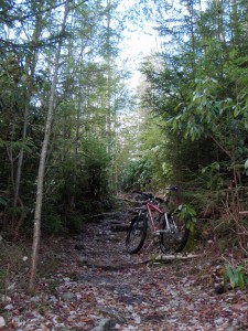
A nd carved out of Rhody thickets
And carved out of Rhody thickets

On way up I noticed a guy alongside the road with h2o jugs: there was a spring pumped out. Never pass up good water so I stopped on my way back into town.

I had wash to do which slipped up on me. I know this because of the number of clean bike shorts I have. Today i had only 2 meaning a wash day.

Stopped at visitor bureau again and asked  questions about how they earn their existence. I learned a whole bunch about web data gathering of user info.

Did wash.

Davis is just a several block long Main street burg. Former bank is now a county gov office. I walked in  admired the original wood work. I noticed the finish on the wood was worn away at the 2 teller windows. With the present economic debacle I could imagine people going to the bank like in the 30’s and the cupboard was empty of our savings.

A small backpacking shop was opened attended by a mother rocking a young baby. I asked about rides and she said that was her husband’s purview and I should check back later. He still wasn’t back when I returned. I left my card and said that I was going into Thomas to a brew pub for a beer. When I entered the pub the bartender asked if I was the biker looking for ride info and she handed me the phone and a phone number. We had a laugh because she sorted out her definition of a biker from the caller. I lacked the tattoos etc of a biker biker.

I drank a jelly jar of their good beer. I saw a picture behind the bar of a guy with a snake. And a guy inn the bar looked like him. I asked if it was he and he said yes. What followed was an educational biology discussion about snakes and their hiberniculum, where a bunch of snakes gather to hibernate. Snakes are affected by hormones and fight other males during mating season but come snuggle time, all bad vibes are past.

Way past dinner time with 2 beers in my belly.

Called Ben, the shop owner with the ride info, and he provided me with info for me to stay another day.

Apparently the 24 hour race craze was born here in Canaan Valley and Ben sent me to the trail system. I found a legal campsite after dark.

Cold and clear night. Need heater and doubled blanket.

Ride here tomorrow then maybe moosey down to Seneca Rocks. I found Slatyfork where my license tabs await. I need to have them on plate by 11/9. Forecast has snow maybe Sat and I do not want to be driving these roads with any snow on them

West Virginia makes 28

Slept OK. I peeked out curtain after daylight and observed a police car out on the street apparently watching for speeders. I passed the police roust test. I seemed to have picked the city stadium overflow parking lot.

Started up the gps & punched in McDonalds for a clean restroom for morning growler. Darn thing put me right in the restroom.

Headed West along Northern edge of MD. Stopped in Cumberland for diesel and quick look at Chesapeake & Ohio canal historical site. Just a piece of original canal has h2o in it. No locks. Cumberland also was a civil war site. So much history never learned and not enough time taken to learn it.

Pushed on up into mountains. Up to Coopers Rock State Forest. Drove in looking for a trail map. None of the bulletin boards had any. Drove back X interstate to unsigned park headquarters. @ oafs were working in a ditch: big bellies and smelling of cigarettes. I asked for a map and the 1 in charge complied. The map was a poor photocopy for the trails. All the roads showed well. Both men said that the trails would be a hard ride as if they knew what a bike was about.

It seems that the public sector documents trails that they want the public to use and sometimes the maps aren’t ground accurate. Today I wandered around again to poorly marked trails. I punched in the TH location just in case.

Trails are loose rocky with these green briers along trail’s edge. Good thorns. I learned that the woods are full of these vines and the only safe riding track is down the center.

Rode to Clay Furnace, another old iron furnace.

Ride started with a flat front tire. I found 1 of those thorns from Fair Hill had worked it’s way thru the tire and into the tube where it broke off. Such a small hole emptied all the air. I patched it. The tire lost air during the ride today and I think there is another broken off thorn. I spoke with somebody somewhere else where there were goat heads who said he ran slime and when the season was finished he threw away his tires as they were full of broken off thorns.

Loose rock, green brier thorns, and archery deer hunters.

Nice day: warm, wore long sleeve bright orange jersey for protection.

Looking for shower. XG has them for $21 and a legal place to stay. Mel, I’m cheap and I whine when $ slip between my fingers. yes, $5.00 for a shower is steep when I really don’t need one. After 3 days of riding, it averages out, plus I had a quiet place to sleep. Darn place prohibits alcohol. What is drunk from a glass remains a secret.

10.55 miles and 1400′. Camped back at elevation of 2150′ like Spokane. Nose bleed.

Still sort of warm. 9:30 and enduring an open van door. But I just shut it.

Election day. May my absentee ballot be counted correctly.

Made an involved 2 burner dinner, a benefit of a legal camping place. Left overs for tomorrow.

Scheduled my fork rebuild with PUSH Industries for right after Thanksgiving. Goodness, spend more than a week in Ohio waiting for the fork’s return.

Off to Seneca Rocks, WVA tomorrow.

Fair Hill & The Shed, just more days in Maryland

Good sleep right out in lights. Bfast & a treat of a Sunday morn paper over a 2nd cup of cold brewed coffee. Left in time to arrive @ jamboree just after registration opening at 9:00AM. I scored a front row parking spot.

It turned out that I did not fall back last night & I was an hour early. Somehow I was introduced to the club pres, the club founder, and a skilled 63 year old rider who was to be my ride leader. I learned a few things from each of them.

Big parking lot filled up. Lots of riders in the hundreds to ride on this big former Dupont estate. First time for me to participate in a big non race party ride. Rode with like 21 riders at start until group split out, still group was about 13. Different riding styles depending upon whom I was behind. Silly riders on hard tail 29ers: their lines are forced, a rear suspension carves a tighter and more varied line. Great trails, tread mostly smooth and added in some interesting tight trails. Shared with horse riders. Chilly w/ brisk wind. Riding in forest crunching the fallen leaves. Like 20 miles in 2 1/2 hours and almost 2000′ vert. The climbs are all short and almost constant: little knibbers up and downs.

Was given some future ride ideas. Founding pres, Ken, winters in FL and he gave me several ride suggestions.

Plan was to ride Patapsco outside Baltimore on Monday. Needed to figure out a road intersection to plug into the GPS. Sort of succeeded. Incredible route: I picked shortest route and I saw scenery that only the locals know about. Nuts on also.

Found a quiet office building parking lot, parked beside a large box truck. Nice to be off main highway for no traffic noise. Parked last row away from building. In Am cars started filling the rows closest the bldg. Needed to time my departure to cync with ebbing commute traffic. Re located Patapsco ride location & plugged it into GPS and headed out. Again, what a route and right on.

The park visitor center was closed so a park map was not obtainable. I decide to bag the ride and drive further to Frederick, MD to ride the watershed. I found a bike shop address and plugged it in to gps. Arrived right at doorstep. Listened to a shop person describe a ride and I bought the map.

Drove up a mountain to about 1200′ on a rocky ridge. I was told that the ride would be rocky. Yes, there were rocks and then there were rock gardens and then there was a hike a bike rock garden. I failed my first garden. Using clipless pedals and being clipped in does allow for a panic foot plant to prevent a body fall slam so I usually chicken out before I might have been able to finesse the move. Getting better at it. Practice track stands and riding in slow tight circles to develop balance and confidence. Some rocks I ride up to and compress the fork that stops forward momentum but the momentum overcomes the compression and I move forward. I still lack the snap for an uphill power stroke. 10.35 miles in 1 3/4 hours.

Plan then was to camp at Grambill Camp Ground (XG) and take a shower. Darn, it was closed, put a hole in my plans. Parked in a grocery store and did internet research for WVA rides. Parking spot looked like I might have been able to pull off a successful sleep but decided that I could find a better one further West where I was heading anyway. Drove into Hagerstown following GPS directions to hospital looking for a dr’s parking lot. Found an unnamed lot near the hospital across the street from a local watering hole. Might get loud tonight.

Shortened daylight hours make finding a spot to crash earlier in the day. The trick is to wait for the business to close, slide in, fix dinner, do internet stuff, sleep, fix bfast, clean up and dash before the business opens. And not get rousted.

Tomorrow is West Virginia: Country Roads Take Me Home.

Drove by Antietam Creek and Harper’s Ferry road.

No pictures taken as the forests appear the same.