Kenosha Pass

<!– /* Font Definitions */ @font-face {font-family:”Cambria Math”; panose-1:2 4 5 3 5 4 6 3 2 4; mso-font-charset:1; mso-generic-font-family:roman; mso-font-format:other; mso-font-pitch:variable; mso-font-signature:0 0 0 0 0 0;} @font-face {font-family:Calibri; panose-1:2 15 5 2 2 2 4 3 2 4; mso-font-charset:0; mso-generic-font-family:swiss; mso-font-pitch:variable; mso-font-signature:-1610611985 1073750139 0 0 159 0;} /* Style Definitions */ p.MsoNormal, li.MsoNormal, div.MsoNormal {mso-style-unhide:no; mso-style-qformat:yes; mso-style-parent:””; margin-top:0in; margin-right:0in; margin-bottom:10.0pt; margin-left:0in; line-height:115%; mso-pagination:widow-orphan; font-size:11.0pt; font-family:”Calibri”,”sans-serif”; mso-ascii-font-family:Calibri; mso-ascii-theme-font:minor-latin; mso-fareast-font-family:Calibri; mso-fareast-theme-font:minor-latin; mso-hansi-font-family:Calibri; mso-hansi-theme-font:minor-latin; mso-bidi-font-family:”Times New Roman”; mso-bidi-theme-font:minor-bidi;} .MsoChpDefault {mso-style-type:export-only; mso-default-props:yes; mso-ascii-font-family:Calibri; mso-ascii-theme-font:minor-latin; mso-fareast-font-family:Calibri; mso-fareast-theme-font:minor-latin; mso-hansi-font-family:Calibri; mso-hansi-theme-font:minor-latin; mso-bidi-font-family:”Times New Roman”; mso-bidi-theme-font:minor-bidi;} .MsoPapDefault {mso-style-type:export-only; margin-bottom:10.0pt; line-height:115%;} @page Section1 {size:8.5in 11.0in; margin:1.0in 1.0in 1.0in 1.0in; mso-header-margin:.5in; mso-footer-margin:.5in; mso-paper-source:0;} div.Section1 {page:Section1;} –>

This post is for 8/31:

Last night Taylor, one of the 3 husbands on the other campers and a mountain biker, filled my notebook pages with ride ideas for the rest of my CO stay and beyond. I reeled him in with the parameter that I have 3 more rides to do in CO, give me 3 good ones. He did.

Said goodbye to the husbands after some sharing of how I am living and plans. Wheels started turning, plans, I’m sure, where cogitating.

Off to Kenosha Pass further S on 285. I drove back into Aspen Park for resupply, found Safeway, super store. Bought h20 etc. Filled my h2o jug and drank. It was tap h2o run thru h2o filter. I anguished a bit & finally turned around & drove back to store. I found the manager & told him of my discovery. He played dumb & no action. He should have tagged the machine as out of order.

Drove up to Kenosha Pass. Getting complacent, I didn’t research the ride. Trail head is back @ 10,000′. The frige quit, and I am riding @ elevation again. Headed S on Colorado Trail towards Georgia Pass. Trail @ first threaded its way over roots, rocks, & aspens. Crossed Jefferson Creek & climb started in earnest as did the roots & rocks. Getting better at making balance moves. I still look down when I get into trouble which throws my balance right off the tire contact patches. At 1 hr 40 min and about 3 miles to go to the pass I stopped for food. I did not replenish my supplies as I again, did not plan this ride. I decided to turn around @ 3:00 because the return trip had climbing in it and I was getting beat. Still took 1 hr 35 min back to TH & that included some fast ST interspersed w/ the climbing.

I have never ridden a trail as rooty & rocky and not beaten by dirt bikes. Add some 20% grade. Real work. Descending was almost as fun except gravity replaced the pedaling.

Taylor laid my route out as ride CO Trail till just before Georgia Pass and drop down JEFFERSON (not Jackson) and intersect with CO Trail @ a road crossing. I turned around before reaching the trail junction. Later when I down loaded the Garmin GPS onto Nat Geo TOPO I learned that I was about .9 mile  from reaching the trail. However, not having a map, I was not able to corroborate the FS hike instructions which indicated a 3 mile road ride to connect trails.

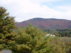
looking out from aspen thicket awaiting rain to let up. Pass way out there

Got rained on several times, neither for very long but the rainfall was intense.

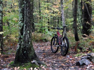
And then the trail got tougher:

forest cover changes with elevation, this is some smoother of the rocky rooty trail

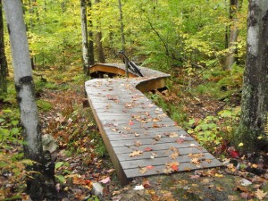
This piece of trail was about the smoothest:

Smooth Single track
Smooth Single track

The downhill was fun picking good lines over rocks & roots. Had a few tree brushes as I chose the close to tree line. No flesh or jersey material left behind.

Back @ van, frige still running @ 10,000’.

Fired up computer @ researched TOPO looking for a place to camp. I decided Bailey which is a@ upper end of road 543, Buffalo Creek road. Lower elevation for frige and ice cream. Abandoned that when I saw the first gravel FS road to the N. Turned off on first spur. Parked in a parking lot. This is where the gas people hang.

Washcloth wipe down. Start dinner and then they arrive: Kid pit racers. There is a short step trail from the parking lot down to the road below. 3 bikes, whrom whroom, about 1 hour of it. They are off approved trails, probably weren’t street legal and were wreaking environmental damage. I fumed, I didn’t take action.

Last night high in the mountains, camped @ 9900’. I ate 1 Hagen Daaz ice cream, 1 more to go. Frige needs to work all night.

Tomorrow is Bergan Peak right near Whippletree. Had enough of their food to last. Just the ride.

Shoes bother my feet & knees. Bottoms of feet get tender. Knee pain might be from cleats placed differently or the shoe is either higher or lower than the other Specialized shoe.

Dark @ 8:00 & chilly.

2nd day buffalo creek

Joy of staying in the same spot is not having to get moving fast in the morning.

Plan is to ride the CDT from camp & hook up somehow w/ Sandy Wash. CDT mostly drops down to road 543 a ways up canyon. Working on handling moves, practicing of sorts for the rocks of the East.

Dropped down to Buffalo XG group site, checked out outhouse: yep CXT.

Chatted w/ rider in parking lot, he described a new trail for me to take to get to Miller’s Gulch. New trail piece built for bikes, I rode it, missed another new piece and road gasline down to the climb up Baldy which I rode stronger.. New shoes worked OK.

Missed Charlie’s again; it goes off homestead and I missed turn off.

Sandy Wash still fun. Down to road 543 and ride home. Hot & dry. Climbed Shinglemill to intersection w/ Morrison. 3 riders gathered. One was guy I met earlier and other 2 are from shared campsite. We all split & I ride up trail to hit CDT and home.

Edge cut out temporarily up on Miller’s but Garmin GPS kept working:26.49 miles & 3130′ vert.

On drier slopes P-pine is climax tree. Forest has a noticeable smell of vanilla.

Forest cover on CDT
Forest cover on CDT

Gasline trail in burn

gasline trail thru either 96 or 2000 fires, almost desert like

Here’s the vision it is desert:

spiny catii type plants line trail in burn

Another Coleman shower. Scab on head appears to be holding the gray matter in.

Drying carpet out from h2o jug leak from yesterday. Carpet is sure taking a beating. From the plastic floor covering in the Element I knew lots of junk come in on shoe bottoms. But is sure feels good on bare feet and looks good. Stain it all one color.

No plans for tomorrow yet.

Buffalo Creek trails

Dirtbag camped behind the bike shop. Awakened by trade people showing up to work.

Crawled out of bed, did exercises, stowed things, and drove towards Pine, looking for a place to fix Bfast.

Tried to find grease gun needle jet to lube Turner bushings. Car parts use a different thread setup so no luck. Concerned that long needle was not sealing tight to grease zerks to force grease into bushings. Must find a bike shop.

Found Buffalo Creek Work station and a trail head. New parking area away from station.

Headed out on rd 543 which turns out to be gated a short ways in which keeps motorized traffic out. All trails appear to be free of dirt bike damage.

Surface is broken down granite all the way to sand size. Old forest fire denuded hills to South of road. Mixed P-pine, a fir, lodgepole, & Doug fir. Very dry. No organic material to bind sand together. Quite a few patches of sand. Big travel bike is way overkill. Trails just flow, hardly a rock and just a few roots.

Up South Shinglehill trail then down Morrison Creek to road, ride the road to Gashouse Gulch climb going North, right on Miller’s Gulch which is a double track. Then the beauty: Sandy Wash descent to road.

Bit of slickrock:

17 miles and another 2000′ day but elevations 6200′ to 8200′

Encountered several groups of riders.

Got water at Work Station & drove S looking for road 550 for dirtbag campsite. Found one. Forest is way dry because of granite. Set up camp. Worked on bike. Set cleats on new Specialized shoes that I had been avoiding the effort.

Painful fuck up: Those that have seen my van saw my cutting board that raises up level with galley but it blocks a good bit of doorway. I stoodup to enter van and smacked my head into the hinge underneath the board. Big gash on my head, probably should have had it stitched, needing maybe 6 to 8 but it clotted very quickly. I’ll just have a big flap of skin scar on my bald spot. Bit of a headache.

Took a Coleman shower. 2 guys with all the camping toys encroached on my spot. They are the forerunners for the forthcoming familes tomorrow. No solitude.

Internet coverage way out here in toolies.

Listening to Old jazz standards on XM radio, Frank Sinatra is fine.