Might there be another forecast? ( I spent 10 summers in S Puget Sound and know that the sun does shine and sometimes for way to many days).
Slept alongside ranger Creek Airstrip just down from Cayuse Pass. No airplanes but lots of heavy camper use but wally weekenders were back home messing their own nests.
Last night I studied the Nat Geo topo map and figured I could ride either Suntop or maybe Ranger Creek w/o a map or guide. I was not eager to pedal the 2,000 to 4,000′ feet for either ride so I headed into civilization, first Greenwater and then finally to Tacoma mall looking for Zilly’s guide book. I drove down rt 410 and viewed clear cuts on mtn sides and right on the road. temperate rain forest produces so much vegetation and big growth but it is an asset and is only of value when it is sawed up. I drove these roads and places when I lived here back in the 80’s yet my memory was holey when navigating. I will say this that there are way too many people for me.
Hanging out in Safeway parking lot in Enumclaw w/ screaming internet. Forecast has rain for next several days. Riding Suntop is special because Rainier is almost close to touch. If lost in clouds the ride is just like any other w/ a long steep logging road climb and a forest trail descent. I called Ranger Creek and Pallisades collectively Corral Pass. I rode Palisades back during Boeing strike when TCS laid me off a second time. Again, a ride w/ a view enhanced by some serious exposure as Rick Vance stated.
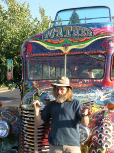
Ken Kesey’s real Further picture: http://www.born-today.com/btpix/kesey_ken.jpg
My picture w/ newer version driven by one of his sons:

Off to other chores b4 heading back into woods.
Wapati wollens in Enumclaw made my famous flamingo hat.
My 60th b-day is 9/9/09 and my addled brain is considering ways to celebrate. sAnyone want to join me in central WA?
pedal on.
Grace races the Leadville 100 on Sat w/ what’s his face Lance somebody. Smoke him, girl.


Are you flashing a gang sign in that photo?
I’m down with you bro